
Cyclone Ian is battering South Carolina, and flash flooding is possible. The storm is also expected to spawn tornadoes in North Carolina and Virginia. Once it passes over those states, Ian will dissipate. Meanwhile, 1.6 million people remain without electricity in Florida.
Cyclone Ian’s path
The impact of Hurricane Ian has been felt across the South Carolina Lowcountry. The storm caused significant flooding and destroyed several piers in the coastal city of Myrtle Beach. The National Weather Service recorded gusts of up to 85 mph in one area, where the storm made landfall on Thursday. On Friday, residents of the Lowcountry continued to assess the damage.
Hurricane Ian has made its second US landfall in Georgetown, South Carolina. It is still a Category 1 hurricane with winds of 85 mph, but its winds will weaken as it moves inland. The storm is still expected to produce heavy rainfall over the Carolinas and Virginia, causing serious flooding in some areas. According to the National Hurricane Center, more than 200,000 people in South Carolina are without electricity.
Impact on South Carolina
Hurricane Ian, now a Category 1 hurricane, is set to hit the coast of South Carolina on Friday. It will bring heavy rains and strong winds and could cause significant damage in some areas. Ian is moving at about 14 miles per hour and has maximum sustained winds of 85 miles per hour. South Carolina officials are warning motorists to use caution and seek alternate routes as the storm approaches the state.
Flood warnings are in place for Charleston and the surrounding area. The storm is expected to bring four to seven feet of storm surge to South Carolina’s coastal areas. Rainfall could range from four to eight inches in the lowlands to 12 inches in some locations.
Impact on the Fort Myers area
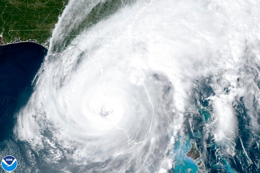
Cyclone Ian is a Category 4 hurricane and is expected to affect Southwest Florida. Its path is still unknown, but forecasters say some areas along Fort Myers Beach could face a six-foot surge. The local school board has decided to keep its doors open in case of an emergency, but the county commissioner ordered a partial evacuation Tuesday.
Cyclone Ian’s storm surge will continue to rise, pushing the coast of southwest Florida. The storm surge is expected to reach its maximum Wednesday afternoon. The timing will depend on where the storm makes landfall and how much development is in the area. The southwest winds will continue to funnel the water into the southwest-facing coastline.
[…] Hurricane Ian is one of the strongest storms to strike Florida in recorded history. It made landfall in Cayo Costa, Florida, and was one of the most damaging hurricanes to hit the state. More than 500 people have been evacuated, and the storm caused widespread flooding and damage. The storm surge and wind speeds have surpassed 150 miles per hour in some areas. […]